01/21/2022
5711 views
48 likes
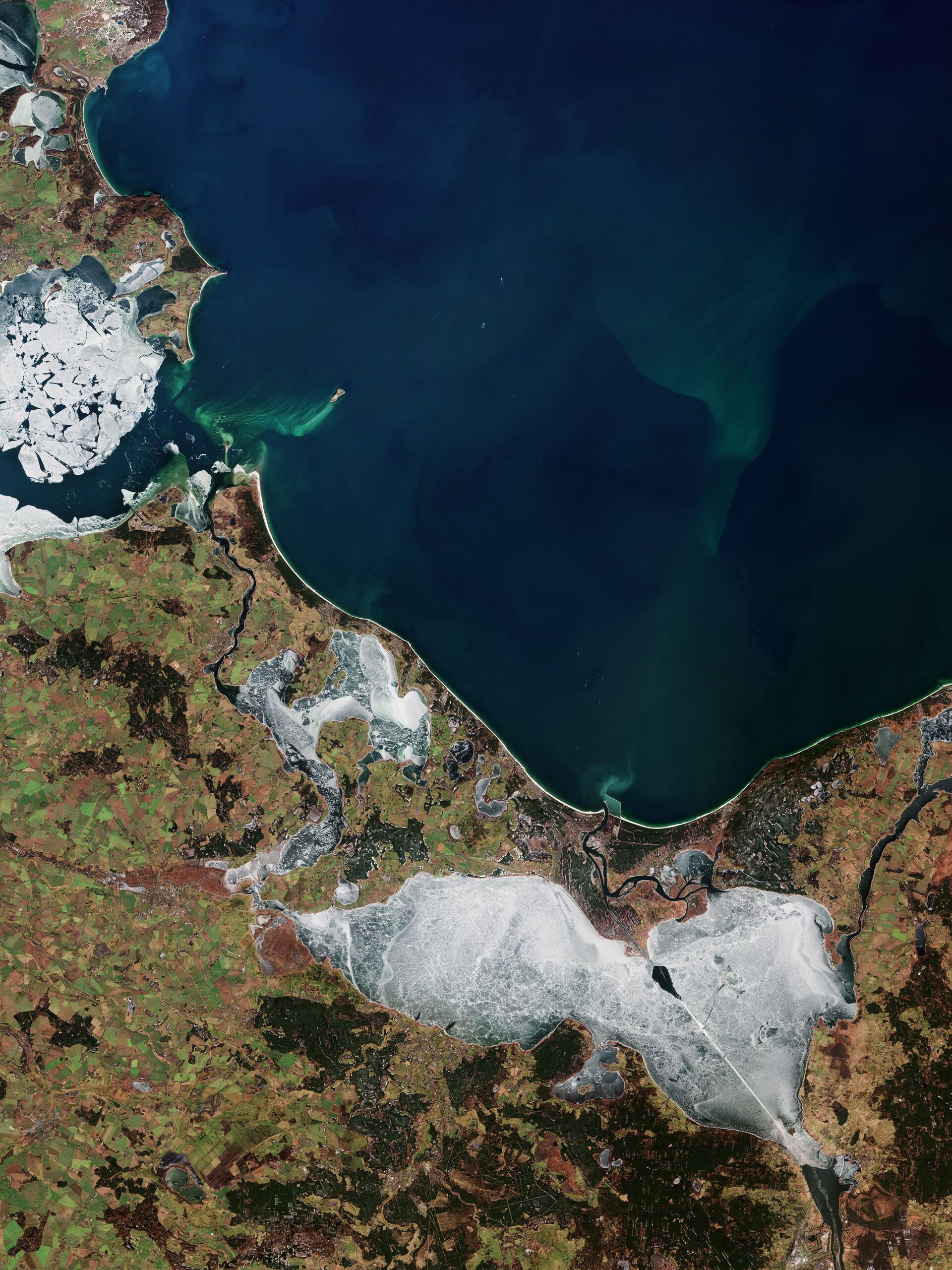
Part of Mecklenburg-Vorpommern, also known as Mecklenburg-Vorpommern, a federal state in north-eastern Germany, is visible in this image taken by the Copernicus Sentinel-2 mission. Part of the north-west coast of Poland can be seen on the right of the picture.
Click on the image below to explore it in its full 10m resolution.
Mecklenburg-West Pomerania stretches along the Baltic Sea Coastal Plain, whose landscape was largely shaped by glacial forces – which deposited materials that created the coastal lowlands now filled with wetlands, streams and lakes.
Mecklenburg-Western Pomerania is one of the most sparsely populated federal states in Germany. Almost two-thirds is covered by arable land, with the main crops being rye, wheat, barley, and hay. The green areas present in this image are most likely winter wheat and winter oilseed rape. Sheep, horses and cattle are typically kept on the region’s pastures.
There are many holiday resorts, untouched nature and the islands of Rügen (partially visible top left) and Usedom (in the middle of the picture) and much more on the Baltic Sea coast of the state. The most populous island in the Baltic Sea, the 445 km² island of Usedom is mostly flat and partly covered by swamps.
The icy Szczecin Lagoon, or Szczeciński Lagoon, dominates this week’s image taken on February 22, 2021. The Haff, an extension of the mouth of the Oder, is divided and drained by Germany and Poland (via the Świna, Peene and Dziwna). rivers) in the Pomeranian Baltic Sea Bay, between Usedom and Wollin.
From the south it is fed by several branches of the Oder, Poland’s second longest river, and several smaller rivers. The clear line above the lagoon represents the shipping route connecting the port cities of Świnoujście and Szczecin.
Several emerald green algal blooms are visible in the image, with the most visible near the Peenestrom, an inlet of the Baltic Sea, on the left of the image. The Peenestrom separates the island of Usedom from the mainland and is an important habitat for waterfowl, especially because of its fish population, such as white-tailed eagles and herons.
Algal blooms are no stranger to the Baltic Sea, with two annual blooms occurring each year (the spring bloom and the cyanobacteria bloom in late spring). Since this picture was taken in February, it is most likely the beginning of a spring bloom.
Although algal blooms are a natural and essential part of marine life, human activities are also said to increase the number of annual blooms. Agricultural and industrial runoff pours fertilizer into the sea and provides additional nutrients that algae need to grow large blooms.
Sentinel-2 is a two-satellite mission designed to provide the coverage and data delivery required for Europe’s Copernicus programme. The satellites are able to systematically map different classes of land cover such as forest, cropland, grassland, bodies of water and artificial covers such as roads and buildings. This type of information can benefit a variety of applications.
This image can also be seen in the Earth from Space video program.